The Sentier Nepisiguit Mi’gmaq Trail (SNMT) is a 150 km backcountry trail located in Northern New Brunswick. It runs roughly on an east west orientation with its eastern trailhead and official starting point (ie. Km 0) at Daly Point Nature Reserve a 10 minute drive from the City of Bathurst. The western trailhead (Km 150) is located in the mountains of Mount Carleton Park deep in the province’s interior.
The SNMT map, guidebook (see FAQ #3) and all official documentation present the trail (and distance markers) as an east-west journey. However, the trail can be done in either direction and thru hikers seem to have a slight preference for the west-east direction.
Tell someone where you are going
Perhaps your most important responsibility before starting a hike is to let someone know which part of the trail you plan to hike and when you are expected to be back. It doesn’t matter if the outing is for an hour, half a day, overnight or a week. Your “guardian” should be informed to phone 911 if you do not return as scheduled.
Register
All multi-day and thru hikers must register and carry a copy of their registration (hiking pass) with them. Day hikers do not need to register.
Map, Compass, GPS
Unless you are familiar with the trail, it is always advisable to carry a map and know how to read it. A compass, a GPS, and a SPOT or INREACH (the latter two are satellite communications devices that work where cell phones don't and can trigger an SOS to a 24/7 staffed global emergency response coordination center) are strongly recommended to bring on multiday or thru hikes. Make sure you have tested and know how to use them prior to hiking.
Forest Fires
Hikers are advised before venturing out on the trail to consult New Brunswick’s Forest Fire websites. One presents forest fire indexes and the other forest fire locations. In severe droughts, government authorities can restrict access or completely close crown lands. Most of the SNMT runs through crown lands and would be directly impacted by such notices.
Low Impact Visitor
It is important that visitors to the SNMT minimize their impact on the wonderful natural environment that surrounds them. As much as possible stay on the marked trail and leave the flora and fauna untouched for others to enjoy. What you carry in, please carry out. Take nothing but photos, leave nothing but footprints.
Pets on the trail
Animal owners are expected to follow Local and Provincial Laws and are responsible for picking up their pet's feces on the trail. Pets should have a harness and be restrained when meeting other hikers and wildlife on the trail. All animals must be vaccinated and tagged.
Food & Drop Box
A hiker can burn from 4000 to 6000 calories per day depending on the distance covered, pack weight and the difficulty of the trail. It’s important to plan your meals and snacks. To minimize your pack weight consider dehydrated meals sold in outdoor stores which are nutritious, filling and light weight. Snacks like nuts and dried fruit provide additional calories between meals. Eat and drink often to stay hydrated and to maintain your energy levels.
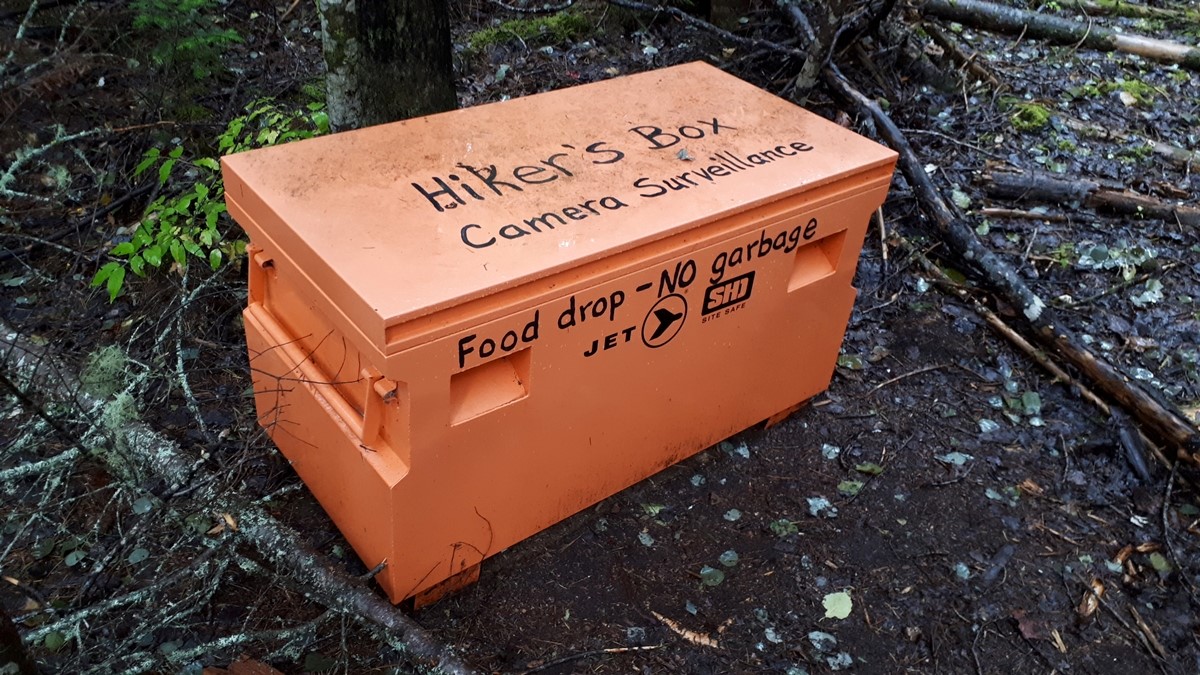
The SNMT has a food drop-box near Access L at coordinates N47° 22’ 28’’ W066° 04’ 20’’. The box is located close to the trail’s halfway point and can be used by hikers to cache food before their hike.
Trail Markers
The entire trail is marked in both directions with Mi’gmaq turtle logo markers (10 cm x 13 cm) in clear acrylic.
Distance markers are placed at 5 km intervals. They also have a turtle logo but on a white background.
There are 21 Access Points and associated Access Paths along the SNMT. They are used by maintenance crews, emergency response teams and hikers to access and exit different trail sections. The Access Points and Paths are marked with turtle logo signs on white backgrounds.
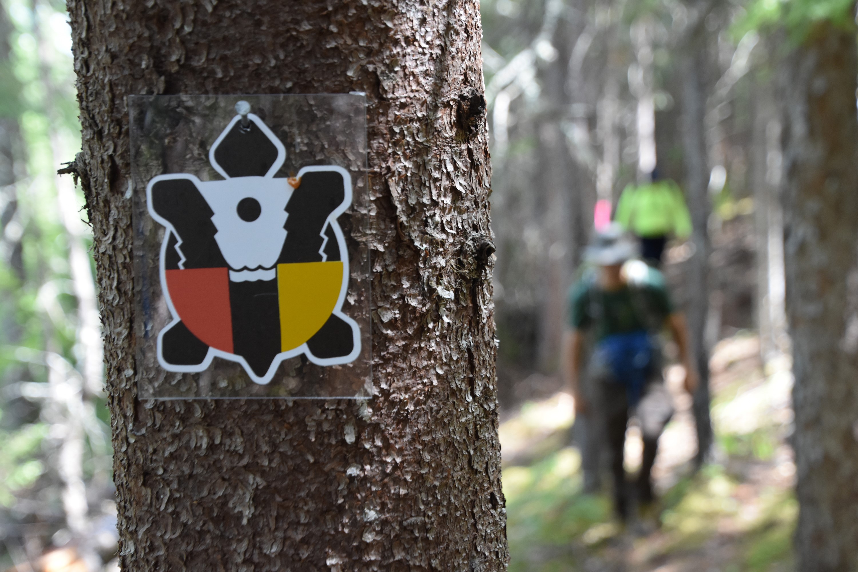
Although the trail is well marked, when arriving at intersections and sharp turns it is advisable to take extra time to look for the next turtle sign before proceeding. Hint: If none are visible (blocked by leaves, etc) look back to see if signs have been posted in the opposite direction. If you lose the Trail, keep in mind that the SNMT generally follows the Nepisiguit River so if you find the river, you should be able to eventually re-locate the trail by travelling parallel to the shoreline.
Know the Flow!
The Sentier Nepisiguit Mi’gmaq Trail is always on the south side of the Nepisiguit River. If you are heading east, you will be hiking with the flow of the river. Going west, you are hiking against the flow of the river.
Cooking
The easiest way to cook is with a compact gas stove. They are inexpensive, powerful and come in a variety of shapes and sizes. They also reduce considerably the risk of forest fires.
Measure food allowances carefully to avoid leftovers. Ideally, you should eat all the food you prepare.
Grey water from cooking and dishwashing should be deposited in a small cat-hole at least 60m from any water sources and campsites and filled in after usage.
No Fires!

Open fires are not permitted on the Sentier Nepisiguit Mi’gmaq Trail. It is recommeded that food be cooked with a compact portable jet stove or similar device.
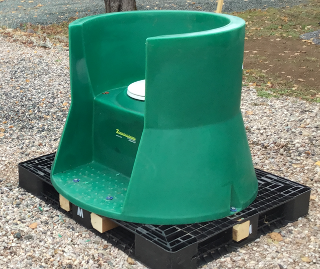
Outhouses and Toilet Etiquette
The SNMT has 3 types of campsites - platform sites, primitive sites and shelter sites. Each of the eight shelter sites has a simple but indestructible plastic outhouse. It is important not to throw refuse into the outhouses to avoid attracting animals.
Where outhouses are not available, hikers should dig a shallow hole off the trail and at least 60 metres from water sources and campsites. When your business is done, cover up the hole including all toilet paper.
FAQ's
Be sure to check the Frequently Asked Questions section. It is full of valuable information and is continually being updated.